Thursday, June 15, 2023

June 15, 2023 - Role playing as DDC, I was tasked with providing DSS for a (fictitious) grass fire near Meade, KS. DSS: Grass fire near Meade, KS For this DSS, requested information included lightning within 10 miles of the site, any significant changes in wind speed and direction, as well as other hazardous weather that would pose a risk to emergency personnel containing the fire. Figure 1. There was ongoing severe convection within the western half of the CWA by the start of my shift, and there was a high likelihood of this convection approaching the DSS site. As shown in Figure 1,  my datasets/tools of choice for tracking severe convection and lightning were as follows: GOES-East Mesosector LightningCast, MRMS Composite Reflectivity, ENTLN intracloud and cloud to ground lightning, surface observations, Time of Arrival Tool, Distance Bearing Tool, and Range Rings Tool. Ground based lightning observations and LightningCast complimented each other nicely when assessing the potential for lightning at the site. Additionally, LightningCast picked up on additional agitated Cu well ahead of the main line of thunderstorms closer to the DSS Site. Using the Time of Arrival tool to track the main cluster of cloud to ground lightning associated with the severe convection was also very useful in providing information on potential to see most lightning via advection, in the absence of additional convective initiation and/or a rapid change in forward speed in ongoing convection. Figure 2. Some consideration was made to not “overwarn” on lightning potential as the main breadth of lightning would likely come from the severe convection still well off to the west. So with this particular scenario, I set an internal threshold of 80% within LightningCast to send a DSS message. The data readout of the parallax corrected LightningCast offered within AWIPS (not shown) was favored over the non-parallax corrected time series (Figure 2), giving higher confidence in the true probability of occurrence used within the DSS message. This gave around a 35 minute lead time before the first strike was detected within 10 miles of the DSS site. Had we used the non-parallax corrected readout values, lead time would have been much shorter, around 10 minutes using 1-minute imagery and less than 10 minutes using 5-minute imagery. This clearly demonstrates the value of using parallax corrected data compared to non-parallax corrected data when performing DSS. Here was the DSS message sent at around 21:10 UTC: Severe thunderstorms have developed around 50 miles to your west, and will likely move over your site between 5:15 pm to 6:30 pm CDT. There is a high chance for storms to remain severe by the time they reach your site, bringing very strong winds over 70 mph out of a direction ranging between northerly to westerly, large hail, heavy rainfall, frequent lightning. We still cannot rule out the potential for a brief tornado, although the chance for a tornado is much lower than previous hazards mentioned. Because of the approaching thunderstorms, the chance for lightning to occur within 10 miles of your site within the next hour (5:15 pm CDT) is over 80%. - 0SMBLSN

 While providing (fictitious) DSS for a grass fire near Meade, KS on June 15, 2023, LightningCast was utilized in notifying the onset of lightning within 10 miles of the DSS site as a line of severe thunderstorms approached. Additionally, consideration was given to the potential for lightning cessation over the site in an effort to give information on potential for the “all clear.”
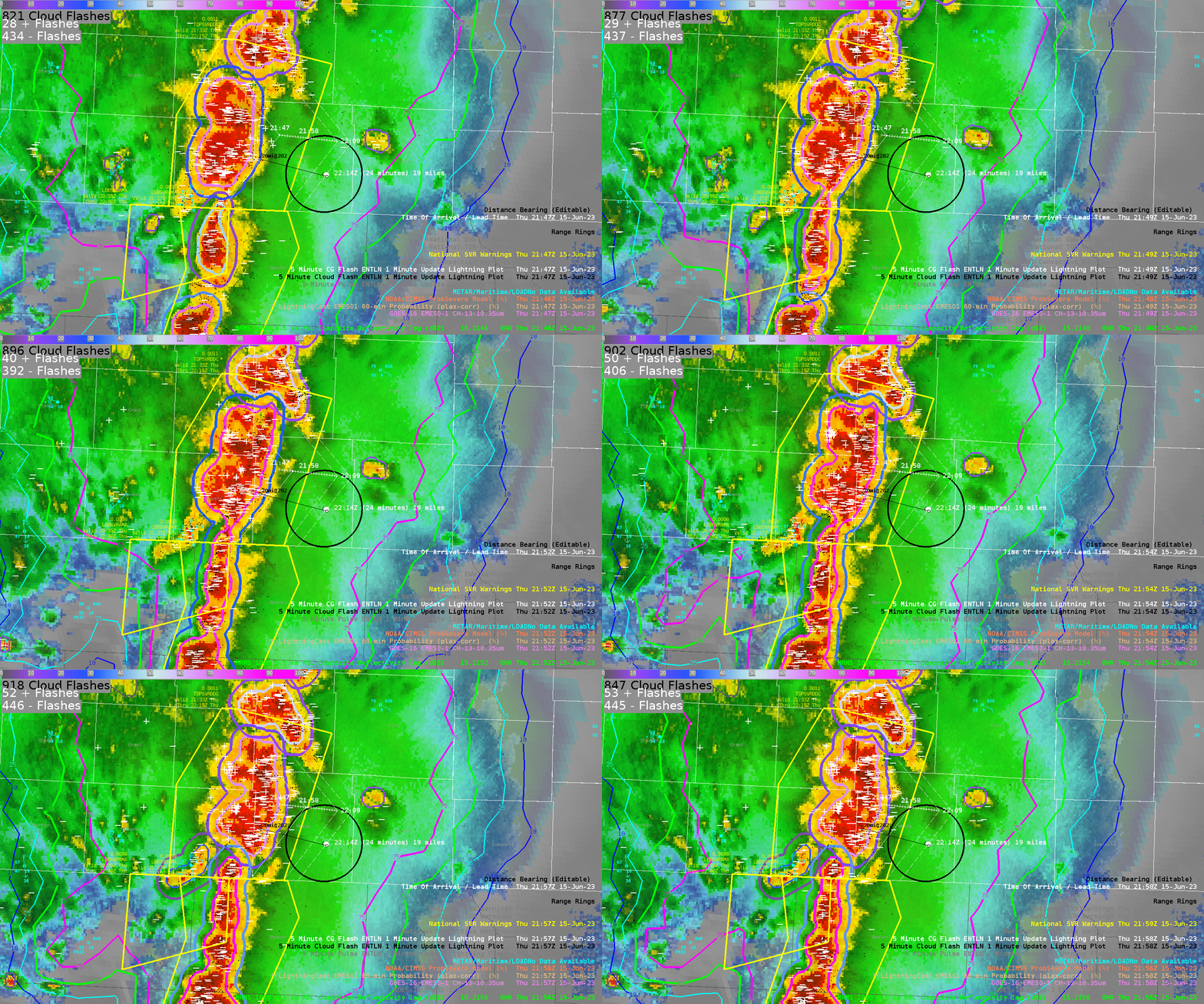
Figure 1.

LightningCast within the trailing anvil portion of the squall line steadily dropped off within the trailing stratiform region. However, these probabilities decreased when cloud to ground lightning was still being observed, with even some strikes occurring in probabilities less than 10%. This can be seen in Figure 1 in the far left hand portion of the animation with CG icons occurring within and outside of the lower contours of LightningCast.

This significantly lowered confidence in tracking the lower probability contours to give an estimated time of cessation.

Here was the DSS message sent at around 21:45 UTC:

As of 4:45 pm CDT, severe thunderstorms are 20 miles west of your site, and continue to approach your site. There is a very high chance these storms remain severe by the time they reach your site, currently expected between 5:15 pm and 5:45 pm CDT, bringing very strong winds over 70 mph out of a direction ranging between northerly to westerly, heavy rainfall, and frequent lightning. We still cannot rule out the potential for a brief tornado and large hail, although the chance for a tornado and hail is much lower than previous hazards mentioned.

Because of the approaching thunderstorms, the chance for lightning to occur within 10 miles of your site within the next hour (5:45 pm CDT) is over 99%.

It is worth noting that even after severe hazards associated with this line of thunderstorms have ended, there will remain over 75% chance of lightning over your site for an additional 1-2 hours, along with the potential for continued gusty winds over 20 mph ranging out of the southeast to northeast.

- 0SMBLSN

No comments:

Post a Comment